Bend Trails to Explore: 15 Places to Walk, Hike, and Ride
October 30, 2026 · Angie Cox
A walk along the river before work. A mountain bike ride through the pines. A summer Saturday spent hiking to a high cascade lake. In Bend, getting outside can become part of an ordinary week.
The variety is a big part of the appeal. There are easy paths close to shops and restaurants, forest trails west of town, open high desert routes, and mountain hikes worth setting aside a full day for.
Whether you’re here for the weekend, dreaming of a second home, or ready to make Bend home, these 15 trails will give you plenty of reasons to spend a little less time indoors.
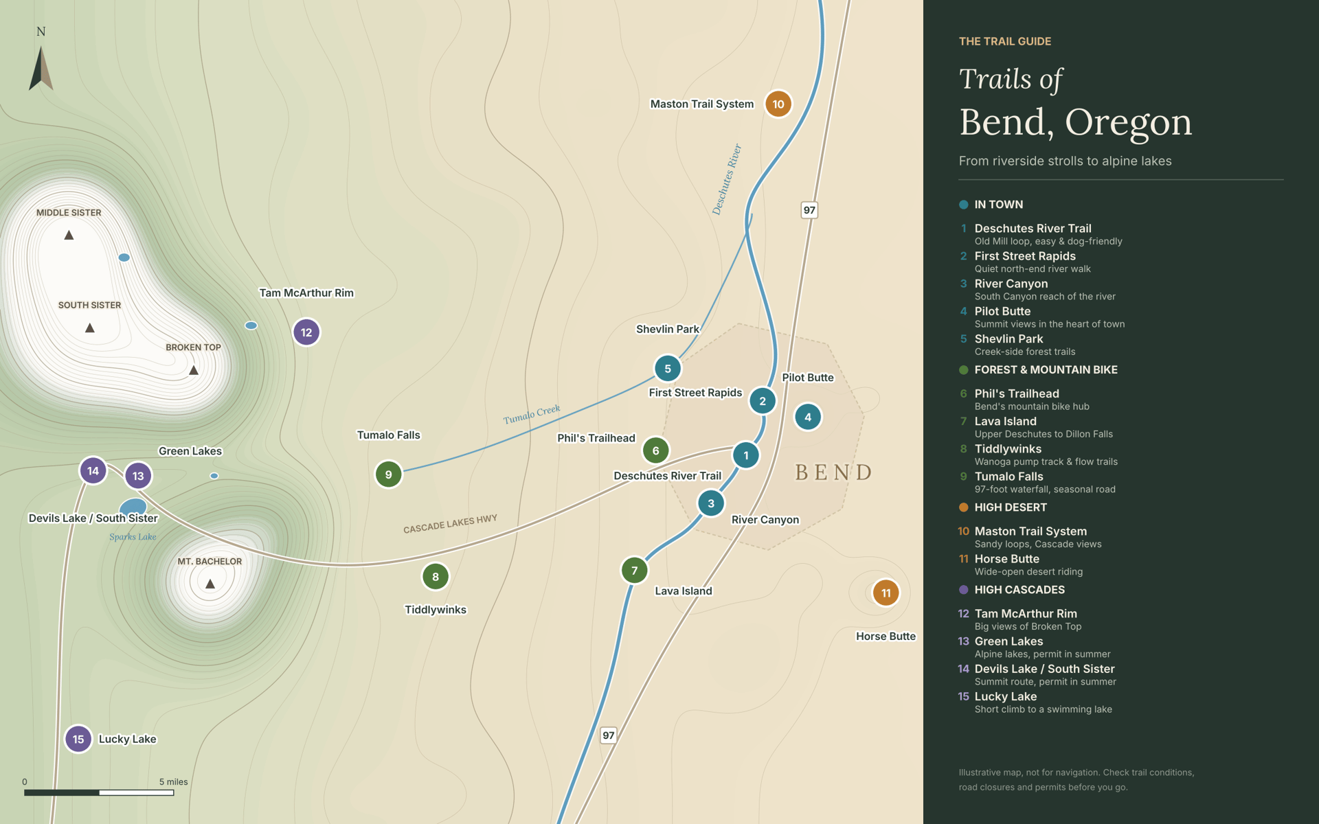
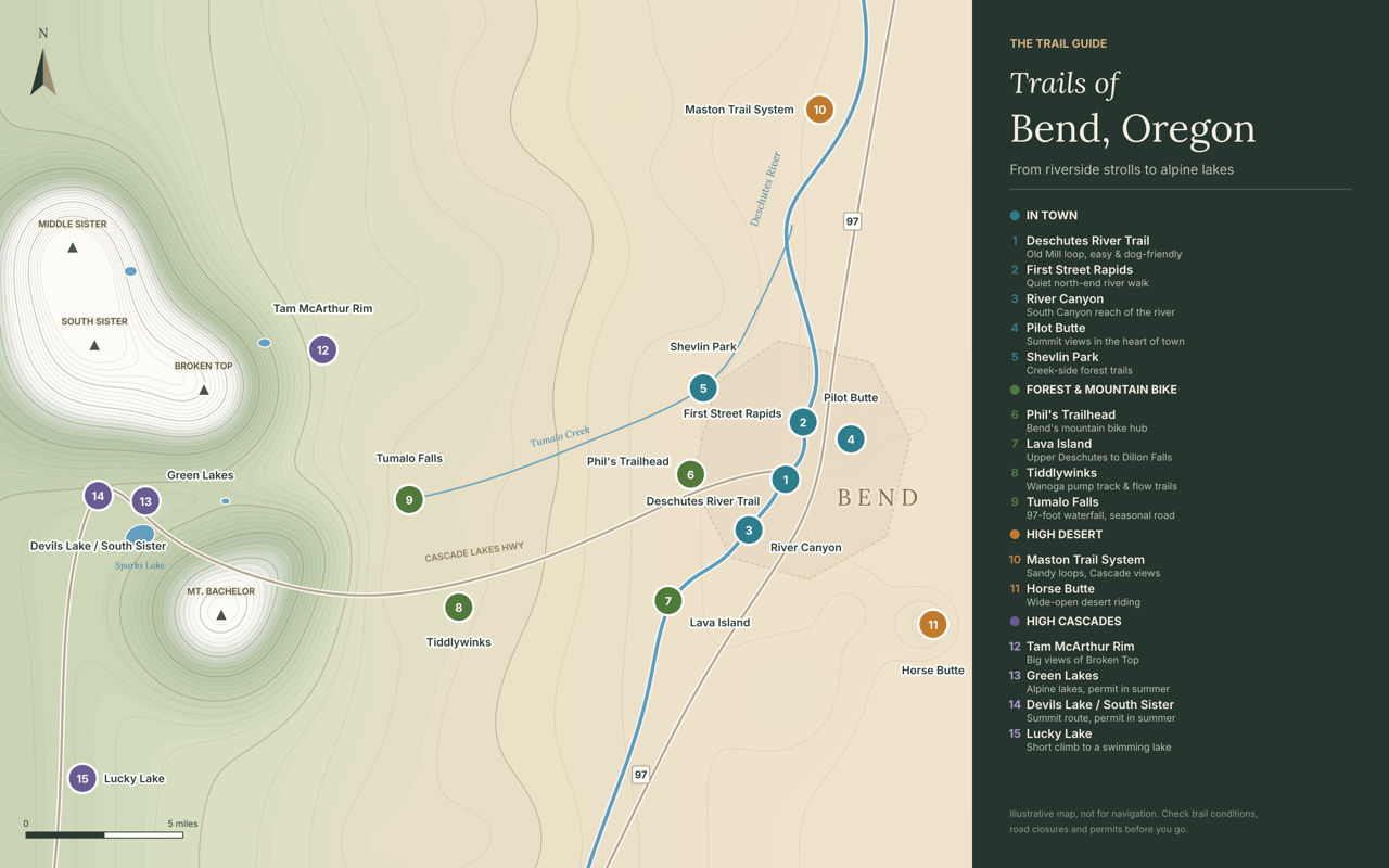
Distances are approximate and depend on the route and turnaround point. Fees and reservation windows below were checked in October 2026; use the linked purchase and reservation pages for the current terms.
In-Town Trails: Easy Ways to Get Outside
These are the places that can turn a quick walk into a daily habit. Many are accessible throughout the year, although winter ice and snow can change the experience.
1. Deschutes River Trail: Old Mill Area
This is Bend's signature walk. The loop runs about 2.5 miles along both banks of the Deschutes between Farewell Bend Park and the Old Mill District, crossing the river on footbridges. The path is wide and mostly flat, so it works for strollers, and there are several places to pause beside the water. Park at Riverbend Park if Farewell Bend's small lot is full. In summer you'll share the river with floaters; in fall the cottonwoods along the bank are simply lovely.
- Route & map: Save the Old Mill Reach map and choose your bridge crossings before starting; loop length varies.
- Dogs & bikes: Dogs must be leashed on the shared paths; use the designated Riverbend off-leash area for off-leash time. Bikes share the paths; slow down around walkers and announce when passing.
2. First Street Rapids and the River Run Reach
Shhhhhh..... At the north end of town, First Street Rapids Park picks up the river trail where most visitors never go. It's a quieter stretch, with river views and places to pause along the trail. There's parking on both sides of the river. It's a good choice when the you're looking for a relaxing spot to cool off...
- Route & map: Download the River Run Reach map; choose an out-and-back toward Sawyer Park or Pioneer Park.
- Dogs & bikes: Dogs must be leashed. Bikes share the designated multiuse trail; yield to pedestrians and announce when passing. The River Run Reach guide shows access points and trail-use guidance.
3. Deschutes River Trail: South Canyon Reach
From River Canyon Park in southwest Bend, a groomed gravel path follows the Deschutes downstream through a small canyon. It feels farther from town than it is, with basalt walls, pine and the sound of the river the whole way. It's an easy, steady walk and a local favorite for dog walks and leash training. It connects north toward the Old Mill if you want to keep going.
- Route & map: Save the South Canyon Reach map. Bridge choices determine the loop, and surfaces are less even than around the Old Mill.
- Dogs & bikes: Dogs must be leashed. Bikes are prohibited on the west-bank canyon trail. For the alternative connection between Bill Healy Bridge and the Haul Road Trail, follow the route along Century Drive described in the South Canyon Reach guide.
4. Pilot Butte
Pilot Butte is an extinct cinder cone that rises right out of east Bend. A trail of about a mile climbs roughly 500 feet to the summit. The reward is one of the best views in Central Oregon: the whole city below you and the Cascades lined up on the western horizon. It's a short, steep workout, and especially good at sunrise or sunset. The summit road is open to cars only part of the year, but the trail stays open year-round.
- Route & map: Save the Pilot Butte trail map and interpretive guide and distinguish the summit trail from the paved summit road.
- Dogs & bikes: Keep dogs leashed. The nature trail is for hiking; cyclists should use the paved summit road. Read Pilot Butte's current notices for construction and road-access changes.
5. Shevlin Park
Shevlin Park covers more than 600 acres along Tumalo Creek on Bend's west edge. The designated Loop Trail runs about 6 miles along the canyon rim and through ponderosa pine, with creek crossings and plenty of shorter options. There's a kids' fishing pond, picnic shelters and some of the best fall color in town when the aspens turn.
- Route & map: Download the Shevlin Park trail map; the designated Loop Trail is approximately 6 miles, with shorter creekside options.
- Dogs & bikes: Dogs must be leashed throughout the park. Use the designated Mountain Bike Trail for a bike-focused route; it is also open to hikers. The Shevlin Park guide describes the park's trail choices.
Forest Trails and Mountain Bike Routes
West and southwest of Bend, the trail options expand into the Deschutes National Forest. These areas include walking routes, waterfall hikes, and mountain bike networks, so choose an outing that matches your activity and experience.
6. Phil's Trailhead
Phil's is a trailhead close to town and the hub of Bend's best-known trail network. The broader Phil's Trail Complex includes more than 200 miles of singletrack across 74 trails in the Deschutes National Forest. Dozens of connected trails fan out from the parking lot, so you can ride a short beginner loop or link together a big day. Trails near the trailhead are mostly mellow and flowy; they get more technical as you head west. A popular combination is climbing Ben's Trail and descending Kent's or Phil's. Hikers and runners use the network too, so stay alert and pick up a trail map at any Bend bike shop.
- Route & map: Download the Tumalo Trail System map, which includes Phil's and connecting trails. Check current signs for trail direction and difficulty before linking a loop.
- Dogs & bikes: For the Ben's/Phil's combination, climb Ben's and descend Phil's; use the linked map and junction signs to identify directional sections. Keep your dog leashed around the trailhead and close to you on shared trails. Review the Phil's Trailhead alerts for forestry-related closures before riding.
7. Lava Island and the Upper Deschutes
The Lava Island trail starts at Meadow Day Use Area and follows the Deschutes past a jumble of black lava rock, twisted junipers and mossy crevices. The first section is about 2.4 miles out and back with roughly 150 feet of elevation gain, which makes it easy for most families. If you want more, keep going upstream past Big Eddy toward Dillon Falls and Benham Falls. You'll find plenty of spots to stop at the water along the way.
- Route & map: Download the Tumalo Trail System map, which shows the Upper Deschutes corridor, and choose your starting day-use area and turnaround before setting out.
- Passes & permits: Parking at Lava Island requires a recreation pass. Buy a $5 Deschutes National Forest day pass before arriving, or buy a $30 annual Northwest Forest Pass. An existing accepted America the Beautiful pass also covers this fee. Lava Island does not offer on-site payment; save your pass before losing cell service.
- Dogs & bikes: At Lava Island, leash dogs at the trailhead year-round and on the Deschutes River Trail May 15–September 15. Bikes use designated shared trails.
8. Tiddlywinks and the Wanoga Area
Tiddlywinks sits off the Cascade Lakes Highway at the Wanoga area. It's known for flowy, jump-filled descents and a pump track at the trailhead that keeps kids busy for hours. There's a restroom and a large trail map on site. In winter the same area becomes Wanoga Sno-Park, a favorite spot for sledding, snowshoeing and fat biking.
- Route & map: Download the Tumalo Trail System map, which includes Tiddlywinks and Wanoga, and select a route that fits your skills. Follow current directional signs.
- Passes & permits: A Sno-Park permit is required November 1–April 30: $4 for one day, $9 for three consecutive days, or $25 for the season. Buy the annual permit through DMV2U, which provides a printable interim permit, or find a permit vendor for daily, three-day, and annual permits. Vendors may add a service fee. Display the permit in the lower-left corner of your windshield.
- Dogs & bikes: Dogs must be leashed in the sno-park and on the sledding hill. The Wanoga guide identifies the dog-friendly winter recreation area. On summer rides, keep dogs close and clear of jump and descent lines; mountain bikers should follow directional arrows on the linked trail map.
9. Tumalo Falls
Tumalo Falls drops about 97 feet over a rock lip into the forest, and the viewpoint is just a few steps from the parking area. For a longer hike, the North Fork Trail climbs past the main falls to a string of smaller waterfalls upstream. The road to the falls is gated in winter, so plan to visit from late spring through fall, or ski and snowshoe in from the closure. Parking fills fast on summer weekends.
- Route & map: Save the Tumalo Trail System map, showing North Fork, Farewell, and Bridge Creek, before choosing a longer route; watershed boundaries affect where you can go.
- Passes & permits: Parking requires a recreation pass. Buy a $5 Deschutes National Forest day pass before arriving, or buy a $30 annual Northwest Forest Pass. An existing accepted America the Beautiful pass also covers this fee.
- Dogs & bikes: North Fork is uphill-only for mountain bikes; plan a permitted return via Farewell/Mrazek rather than riding back down North Fork. Dogs and bikes cannot enter the Bend Municipal Watershed, including the Bridge Creek route. Dog owners should choose an out-and-back that stays outside the watershed. See the Tumalo Falls access rules and linked trail map.
High Desert Trails: Juniper, Sagebrush, and Open Views
Bend's outdoor lifestyle extends beyond the forest. Lower-elevation desert routes can offer options when mountain trails are snow-covered, although mud, ice, and freeze-thaw conditions still matter.
10. Maston Trail System
Maston sits on BLM land between Bend and Tumalo, with miles of hard-packed sandy trails for hikers, runners, mountain bikers, and horseback riders, with separate bike and horse routes. Most routes are beginner-friendly, with a few rockier sections for variety. The full outer loop runs about 12 miles with only around 600 feet of climbing. The views of the Cascades are excellent, especially at sunset. There's little shade, so skip midday in summer and bring water.
- Route & map: Download the BLM Maston trail map and brochure and select a walking, biking, or equestrian route; bike and horse routes are separated.
- Dogs & bikes: Bike and horse routes are separated; follow the activity symbols on the BLM map. Keep dogs within sight and under control, particularly around horses and riders. BLM notes that the area is open to trapping, another reason to keep dogs close. Read Maston's visitor guidance.
11. Horse Butte
Horse Butte lies southeast of town, past the edge of the suburbs. Trails loop around the butte through open desert, with open views toward the mountains. It's popular with mountain bikers and trail runners who want wide-open terrain. The access roads are rough in spots, so a higher-clearance vehicle helps.
- Route & map: Review the Forest Service closure map and current closure order before making plans. Horse Butte Trailhead and the butte area are closed under the order effective May 1, 2026–April 30, 2027, unless rescinded sooner.
- Dogs & bikes: The closure applies to hikers, cyclists, and dog walkers alike. Choose an open alternative such as Maston while Horse Butte Trailhead and the butte area remain closed.Cascade Mountain Hikes: Plan a Little Further Ahead

These hikes are farther from town and more dependent on snowpack, road access, and weather. Summer and early fall usually offer the most practical hiking window, but conditions vary each year.
12. Tam McArthur Rim
This trail starts near Three Creek Lake, south of Sisters, and climbs steeply for the first couple of miles before leveling onto a high rim. From the main viewpoint, about 5 to 6 miles round trip, you look straight across at Broken Top and the Three Sisters, and on clear days north to Mount Jefferson and Mount Hood. Strong hikers can continue toward Broken Hand for a longer day. The last stretch of road to the trailhead is washboarded, so take it slow.
- Route & map: Download the Three Sisters Wilderness map, which includes Tam McArthur Rim; choose the main viewpoint as your turnaround unless prepared for a longer mountain route.
- Passes & permits: June 15–October 15, reserve a Tam McArthur Rim day-use permit. The processing fee is $1 per person. Permits are released at 7 a.m. Pacific, 10 days and two days before the hiking date. Select the correct date and trailhead, and save a PDF or print a copy to carry.
- Dogs & bikes: Bicycles, including e-bikes, are prohibited in the wilderness. Keep dogs controlled around wildlife and away from rim edges; keeping them leashed is the practical choice on exposed sections. The Forest Service leash map identifies the separate seasonal leash zone around South Sister and Green Lakes.
13. Green Lakes
Green Lakes is a scenic mountain hike near Bend. The trail follows Fall Creek past waterfalls and a towering obsidian lava flow to a cluster of glacier-fed lakes between South Sister and Broken Top. It's about 9 miles round trip with a steady climb. From June 15 through October 15, wilderness entry requires the appropriate day-use or overnight permit; use the reservation links below.
- Route & map: Download the Three Sisters Wilderness map, which includes Green Lakes and Soda Creek, and choose your lake-basin turnaround; exploring farther adds mileage.
- Passes & permits: June 15–October 15, reserve a Green Lake/Soda Creek day-use permit. The processing fee is $1 per person; permits are released at 7 a.m. Pacific, 10 days and two days ahead. Save a PDF or printed copy. Parking is separate: buy a $5 day pass or a $30 annual Northwest Forest Pass, or use an existing accepted America the Beautiful pass.
- Dogs & bikes: Dogs must be leashed July 15–September 15 on Green Lakes Trail and within the mapped seasonal leash zone. Bicycles, including e-bikes, are prohibited in the wilderness.
14. Devils Lake and South Sister
Devils Lake is a short walk from the trailhead: a small, startlingly green lake ringed by lava rock and forest. The same trailhead is the starting point for the South Sister climb, a very demanding mountain route of about 12 miles round trip with close to 5,000 feet of elevation gain in snow-free conditions. The summit, at over 10,000 feet, looks down on a crater lake and across most of Central Oregon. Start early, carry plenty of water and layers, and reserve the required seasonal permit using the link below.
- Route & map: Download the Three Sisters Wilderness map, which includes the South Sister route. From the Devils Lake parking area, use the Elk–Devils Trail highway underpass to access the climb, as directed on the permit page. A lakeside stop and the summit climb require very different time, fitness, and preparation.
- Passes & permits: June 15–October 15, reserve a Devils Lake/Wickiup day-use permit for the South Sister route. The processing fee is $1 per person; permits are released at 7 a.m. Pacific, 10 days and two days ahead. Save a PDF or printed copy. Parking is separate: buy a $5 day pass or a $30 annual Northwest Forest Pass, or use an existing accepted America the Beautiful pass.
- Dogs & bikes: Bicycles, including e-bikes, are prohibited in the wilderness. Dogs must be leashed on the South Sister route July 15–September 15; sharp volcanic footing also matters when deciding whether to bring a dog.
15. Lucky Lake
Lucky Lake is the easiest of the mountain hikes. A trail of about 1.25 miles climbs gently through the forest to a quiet lake that's warm enough for a summer swim. It's a good fit for families and a short alternative when the bigger trails are crowded. Get there early on summer weekends, and expect the access road to be closed by snow for about half the year.
- Route & map: Download the Three Sisters Wilderness map, which includes Lucky Lake and Senoj Lake, and identify your lake turnaround before starting.
- Passes & permits: June 15–October 15, day hikers fill out a free self-issued wilderness permit at the trailhead before starting; carry the visitor copy. For camping, reserve a Central Cascades Wilderness overnight permit, selecting Lucky Lake and your entry date. The overnight reservation fee is $6 per group permit. Additional overnight permits are released seven days before the trip at 7 a.m. Pacific. See Lucky Lake's permit instructions.
- Dogs & bikes: Bicycles, including e-bikes, are prohibited once the trail enters the wilderness. Keep dogs under control around wildlife and other hikers; carry a leash and use it when passing others. Lucky Lake's Forest Service guide lists wilderness restrictions.
A little planning makes these outings much easier to enjoy.
- Check current conditions. Review Deschutes National Forest alerts for trail and forestry closures, TripCheck for highway conditions, and Bend Park & Recreation notices for city-park updates.
- Choose the right route. Trail networks offer multiple options. Save the linked maps before losing cell service.
- Separate parking passes from hiking permits. A parking pass doesn't replace a required wilderness entry permit.
- Book the correct wilderness entry. Use the trail-specific reservation links above. For overnight trips at the wilderness trailheads, reserve an overnight permit for June 15–October 15; the reservation fee is $6 per group permit. About 40% of overnight availability opens on the first Tuesday in April, with the remainder released seven days ahead at 7 a.m. Pacific. Carry your permit on the trip.
- Bring water, layers, and sun protection. Exposed desert trails and mountain weather require different preparation.
- Use the trail-specific dog and bike guidance above. For a broader overview, see Bend park dog rules and the Forest Service seasonal leash map.
- Protect the trails. Avoid muddy routes, stay on established paths, and pack out litter and dog waste.
Finding a Home Near the Trails You'll Actually Use
Trail access can mean different things when you're choosing a home in Bend. A river path within walking distance, a nearby mountain bike connection, and a shorter drive toward the mountains each offer something different.
Parts of west Bend offer convenient access toward Shevlin Park and the forest networks. Some southwest neighborhoods connect to the river trail, while east Bend offers proximity to Pilot Butte and routes toward the high desert. Actual access depends on the property, street connections, and designated trail entrances.
Whether you're relocating or buying a second home, think about the outings you'd enjoy on an ordinary Tuesday as well as a vacation weekend. That helps narrow the neighborhood search in a practical way.
Looking for a Bend home that fits the way you like to get outside? Book a Call with Angie to talk through neighborhoods, trail access, and the details that matter most to you!